|
Alcune note descrittive delle Langhe e del Roero. . . . .
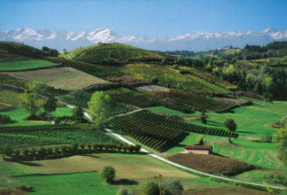
Pochi scenari possono superare, in
quanto a bellezza e suggestività, quello offerto dalle langhe a dal Roero
nella stagione autunnale: gli
ordinati vigneti carichi a settembre di uva matura, i boschi dai caldi colori
ottobrini,
le prime impalpabili nebbie di
Novembre in cui si muovono i cercatori di tartufi accompagnati dai loro
inseparabili
cani, sono sicuramente gli
ingredienti principali, pur se stereotipati, del fascino che questa terra sa
emanare.
Ciò nonostante riteniamo che le
Langhe ed il Roero, a differenza della montagna, possano costituire terreno
ideale per la mountain Bike in
qualunque periodo dell'anno, tempo permettendo, ed offrire al ciclista un
ambiente ogni volta diverso, ma
sempre estremamente accattivante.
a parte il periodo dell'innevamento,
decisamente limitato in questi ultimi anni, e del disgelo,
le sterrate delle Langhe e del Roero
sono sempre percorribili. Unico impedimento, il tempo:
dopo piogge intense il fondo
argilloso può aderire alle coperture fino a bloccare completamente
l'avanzamento delle ruote.
Some descriptive notes of the Langhe and Roero. . .
Few scenarios can overcome, in terms
of beauty and suggestiveness, that offered by the Langhe and the Roero
in the autumn season: the neat vineyards loaded in September with ripe grapes,
the woods with warm, octangy colors,
the first impalpable mists of November in which the truffle hunters move with
their inseparable
dogs, are definitely the main ingredients, even if stereotyped, of the charm
that this land can emanate.
Nevertheless we believe that the Langhe and Roero, unlike the mountain, can
constitute land
ideal for mountain biking at any time of the year, weather permitting, and offer
the cyclist a
environment every time different, but always extremely appealing.
apart from the period of snowmaking, decidedly limited in recent years, and of
the thaw,
the dirt roads of the Langhe and Roero are always passable. The only impediment,
the time:
after intense rains the clayey bottom can adhere to the roofs until it is
completely blocked
the progress of the wheels.
Le Langhe. . .
Le langhe ed il Roero sono territori
collinari adiacenti suddivisi dall'ampia valle del fiume Tanaro.
Terre piemontesi profondamente
differenti sotto il profilo geologico e paesaggistico.
Non semplici piani inclinati, ma
colline ora dolci ora impervie, ricche di fascino, di tradizione e di cultura.
la Terra di Langa, nota per ragioni
enogastronomiche, è un infinito mare di colline ampiamente distese
sulla destra del fiume Tanaro, nella
parte centro-meridionale del Piemonte, fino ai confini con la Liguria.
The Langhe. . .
The Langhe and the Roero
are adjacent hilly territories subdivided by the wide valley of the river
Tanaro.
Piedmontese lands profoundly
different from a geological and landscape point of view.
Not simple inclined planes, but
hills now sweet now impervious, full of charm, tradition and culture.
the Land of the Langhe, known for
food and wine reasons, is an infinite sea of widely spread hills
on the right side of the river Tanaro, in the central-southern part of Piedmont,
up to the borders with Liguria.
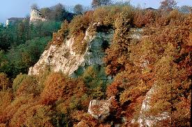
Geografia delle Langhe:
Il territorio delle langhe è
delimitato ad est dalla Bormida di Spigno e dal Tanaro ad ovest.
Il sistema collinare degrada a nord
verso le colline astigiane, dalle quali è separato dal corso del Tinella,
mentre a Sud la linea Ceva-Carcare
rappresenta l'immaginario confine con la porzione terminale delle alpi Liguri.
Il territorio di Langa è solcato da
quattro nervature orografiche principali, profondamente incise dalle Valli del
Belbo,
della Bormida di Millesimo e
dell'Uzzone.
la facile erodibilità del suolo ha
frastagliato le lunghe dorsali principali in una miriade di creste secondarie
che
racchiudono vallecole e rittani.
Il multiforme sistema collinare, che
raggiunge la massima altezza sulla collina di Monbarcaro (896 m.), crea
eterogenei scenari paesaggistici
caratterizzati ora da scoscese zone erosive, ora da dolci declivi.
Geography of the Langhe:
The territory of the Langhe is bordered to the east by the Bormida di Spigno and
the Tanaro to the west.
The hilly system slopes to the north towards the hills of Asti, from which it is
separated from the course of the Tinella,
while to the south the Ceva-Carcare line represents the imaginary border with
the terminal portion of the Ligurian Alps.
The territory of Langa is furrowed by four main orographic ribs, deeply engraved
by the Valle del Belbo,
of the Bormida di Millesimo and Uzzone.
the easy erodibility of the
ground has jagged the long main ridges in a myriad of secondary ridges that
they contain vallecole and rittani.
The multiform hilly system, which reaches the maximum height on the hill of
Monbarcaro (896 m.),
Creates heterogeneous
landscape scenarios now characterized by steep areas of erosion,
now with gentle slopes.
La storia delle Langhe:
L'origine del nome Langhe si perde
nella notte dei tempi ed è piuttosto controversa.
l'ipotesi più comunemente accettata,
che derivi dalla conformazione delle colline, vere "lingue" di terra,
è avvalorata dalla consuetudine di
definire "Langa" la cresta della collina, identificandola con il nome
del paese o della chiesa che vi
sorge (ad esempio "la Langa di Castino" o "la Langa di S. Elena").
The history of the Langhe:
The origin of the Langhe name is lost in the mists of time and is rather
controversial.
the most commonly accepted hypothesis, deriving from the conformation of the
hills, true "languages" of land,
is supported by the custom of defining "Langa" the crest of the hill,
identifying it with the name
of the village or church that stands there (for example "the Langa di Castino"
or "the Langa di S. Elena").
Le tradizioni, la cultura.
Le langhe e l'uomo sono legate da
vincoli indissolubili, che hanno permesso nei secoli
la reciproca sopravvivenza.
gli incredibili terrazzamenti,
frutto di interminabili giornate di lavoro, i lunghi filari dei vigneti
che ricamano con magiche geometrie
le pendici esposte delle colline, le sperdute cascine di robusta pietra di
Langa,
i paesini prepotentemente arroccati
sulle lunghe dorsali, stretti attorno al castello, alla chiesa e all'osteria,
fanno subito pensare al patto
stretto fra l'uomo e la terra, alla vita dura e semplice della gente di Langa.
Traditions, culture.
The Langhe and the man are bound by indissoluble bonds,
which they have allowed over the
centuries mutual survival.
the incredible terraces, the result of endless days of work, the long rows of
vineyards
embroidering the exposed slopes of the hills with magical geometries, the remote
farmsteads of robust Langa stone,
the villages dominantly perched on the long ridges, tight around the castle, the
church and the inn,
they immediately think of the pact between man and earth, the hard and simple
life of the people of the Langhe.
. . . e il Roero.
Il Roero con il suo territorio
angusto, ma così eterogeneo ed accidentato è situato sulla sinistra del fiume
Tanaro
e può considerarsi l'ultima
propaggine delle colline astigiane, fino ai confini della provincia torinese.
Non più langa, quindi con la quale
talvolta viene erroneamente confuso, ma al più, lontana eco del Monferrato
nell'area nord-orientale della
"provincia granda" al centro del Piemonte.
. . . and the Roero.
The Roero with its narrow territory, but so heterogeneous and bumpy is
located on the left of the river Tanaro
and can be considered the last offshoot of the Asti hills, up to the borders of
the Turin province.
No longer langa, then with which it is sometimes mistakenly confused, but at
most, distant echo of the Monferrato
in the north-eastern area of the "granda province" in the center of Piedmont.
Geografia del Roero:
Il territorio del Roero occupa il
settore nord-orientale della provincia di Cuneo, estendendosi nel territorio
di 24 comuni, con piccoli
sconfinamenti nell'astigiano e nel torinese.
E' delimitato a sud dal fiume
Tanaro, ad est e a nord dai confini con le provincie di Asti e di Torino, mentre
ad ovest il confine è costituito dai
limiti giurisdizionali di Bra, Sanfrè e Sommariva Bosco.
Morfologicamente la regione appare
divisa in due zone profondamente differenti, situate ai lati opposti di una
secante mediana che la attraversa e
che coincide con il ciglio delle "Rocche".
Ad ovest si estende un altopiano
uniformemente ondulato che digrada verso la pianura torinese.
Ad Oriente, invece, si configura un
complesso sistema collinare a struttura labirintica, profondamente inciso
nei terreni terziari costituiti da
sedimenti di deposizione marina, emersi dall'antico "Mare Padano".
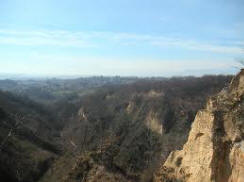
Gli imponenti fenomeni erosivi che
caratterizzano questa zona furono generati dalla "cattura del Tanaro",
raro caso di deviazione del corso di
un fiume, curioso avvenimento che si verificò tra 220.000 e 150.000 anni fa.
Il fiume Tanaro che da Bra scorreva
nella piana carmagnolese fino alla confluenza con il fiume Po verso Torino,
fu catturato da un piccolo corso
d'acqua in erosione regressiva, che determinò la deviazione ad oriente
attraverso il territorio
Albese, provocando effetti
sconvolgenti sulla morfologia dei sabbiosi terreni del Roero.
questo evento determinò la
formazione delle Rocche, magnifici spaccati naturali creatisi sullo spartiacque
tra la vecchia
e nuova vallata del Tanaro, sulla
direttrice Bra, Pocapaglia, Sommariva Perno, Baldissero, Montaldo, Monteu, S.
Stefano Roero e Montà.
Geography of the Roero:
The Roero territory
occupies the north-eastern sector of the province of Cuneo,
extending into the
territory of 24 municipalities,
with small encroachments in
the Asti area and in the Turin area.
It is bordered to the south by the river Tanaro, to the east and north by the
borders with the provinces of Asti and Turin.
to the west the border is constituted by the jurisdictional boundaries of Bra,
Sanfrè and Sommariva Bosco.
Morphologically, the region appears to be divided into two deeply different
zones,
located on opposite sides
of one median secant that crosses it and that coincides with the edge of the
"Rocche".
To the west lies a uniformly undulating plateau that slopes towards the Turin
plain.
In the East, instead, there is a complex hilly system with a labyrinthine
structure, deeply engraved
in tertiary soils consisting of marine deposition sediments, emerged from the
ancient "Mare Padano".
The imposing erosion phenomena that characterize this area were generated by the
"capture of the Tanaro",
rare case of deviation of the course of a river, a curious event that occurred
between 220,000 and 150,000 years ago.
The river Tanaro that from Bra flowed in the Carmagnola plain to the confluence
with the river Po towards Turin,
it was captured by a small stream in regressive erosion, which determined the
deviation to the east across the territory
Albese, provoking disturbing effects on the morphology of the sandy soils of the
Roero.
this event determined the formation of the Rocche, magnificent natural splits
created on the watershed between
the old and the new Tanaro
valley, on the Bra, Pocapaglia, Sommariva Perno, Baldissero, Montaldo,
Monteu, S. Stefano Roero
and Montà lines.
La storia del Roero:
Il Roero fu interessato da precoci
insediamenti preistorici, seguiti da una capillare presenza dei liguri,
successivamente
colonizzati dai Romani.
con l'Impero Romano questo
territorio fu attraversato da numerose "stratae" per collegare Asti, Alba e
Pollenzo, coronate
da opere di viabilità minore,
sorvegliate da castelleri.
la zona a detta di Plinio era già
nota per i vini e le anfore.
The history of the Roero:
The Roero was affected by early prehistoric settlements, followed by a capillary
presence of the Ligurians,
later colonized by the
Romans.
With the Roman Empire this territory was crossed by numerous "stratae" to
connect Asti, Alba and Pollenzo,
crowned from minor road
works, supervised by castelleri.
The area according to Pliny was already known for its wines and amphorae.
Le tradizioni, la cultura.
i segni della presenza umana nel
paesaggio rurale del Roero si identificano con la secolare lotta contro il bosco
ad
opera dell'uomo, che indomito ha
saputo superare epidemie e carestie, modellando le impervie colline a seconda
delle
bocche da sfamare.
l'agricoltura del Roero fu una
tipica forma di sussistenza con la diffusione di piccole proprietà contadine:
poche
manciate di giornate di terra con la
cascinotta, il campo, il prato, il bosco ed uno o due "vignot" (PICCOLO VIGNETO)
lontani fra loro per salvaguardare
uno in caso di grandine.
Traditions, culture.
The signs of human presence in the rural landscape of the Roero are identified
with the age-old struggle
against the forest ad man's
work, which indomitable has been able to overcome epidemics and famines,
modeling the impervious
hills according to the mouths to feed.
Roero agriculture was a typical form of subsistence with the spread of small
peasant properties:
few handful of days of land
with the cascinotta, the field, the meadow,
the forest and one or two
"vignot" (PICCOLO VINEYARD)
far from each other to
protect one in case of hail.

|